Benin
Population
8,439,000 peopleCapital
Porto NovoCurrency
West African CFA francLanguages spoken in Benin
FrenchMap of Benin
Area in square kilometers
112,622 km2Gross domestic product per capita
$ 1,176
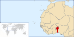
Benin (pronounced /bɨˈnɪn/), officially the Republic of Benin, is a
country in Western Africa. It borders Togo to the west, Nigeria to the
east and Burkina Faso and Niger to the north; its short coastline to
the south leads to the Bight of Benin
of Benin has no direct connection to Benin City in modern Nigeria, nor
to the Benin bronzes.
The new name was chosen for its neutrality. Dahomey was the name of
the former Kingdom of Dahomey, which covered only the southern third
Benin is divided into 12 departments (French: départements), and
subdivided into 77 communes. In 1999, the previous six departments
were each split into two halves, forming the current 12. The six new
departments have not been assigned an official capital yet.
Present day Benin was the site of Dahomey, a prominent West African
kingdom that rose in the 15th century. The territory became a French
Colony in 1872 and achieved independence on 1 August 1960, as the
Republic of Benin
The economy of Benin remains underdeveloped and dependent on
subsistence agriculture, cotton production, and regional trade. Growth
in real output has averaged around 5% in the past seven years, but
rapid population growth has offset much of this increase. Inflation
of Benin-Niger boundary, including tripoint with Nigeria, remains
undemarcated; in 2005, Nigeria ceded thirteen villages to Benin, but
border relations remain strained by rival cross-border gang clashes;
talks continue between Benin and Togo on funding the Adjrala
hydroelectric dam on the Mona River
Benin is a country in West Africa. It borders Togo to the west,
Nigeria to the east and Burkina Faso and Niger to the north.
Understand
-
and Kereku lost to Nicephore Soglo—Benin was thus the first African
nation to successfully coordinate a peaceful transfer of power from a
dictatorship to a functioning democracy. Soglo remained president
through 1996, but his administration was marred by poor economic
Benin, compared to its neighbors, is geographically smaller, being
112,620 square kilometers—the size of Honduras or the U.S. state of
Ohio. The country is basically divided into five geographic zones,
from south to north: the Coastal plain, the plateau, the elevated
Benin City is located in Nigeria
Benin CityBenin City Location in Nigeria
Coordinates: 6°19′N 5°36′E / 6.317°N 5.6°E / 6.317; 5.6
Country
Nigeria
State
Edo State
Benin was visited by the Portuguese in about 1485, historical Benin
grew rich during the 16th and 17th centuries on the slave trade with
Europe, carried in Dutch and Portuguese ships, as well as through the
export of some tropical products.
The Bight of Benin's shore was part of the so-called "Slave Coast",
from where many West Africans were sold (usually by slave raiders) to
foreign slave traders. In the early 16th century the Oba sent an
ambassador to Lisbon, and the King of Portugal sent Christian
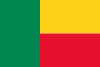
Flag of Benin is two equal horizontal bands of yellow (top) and red (bottom) with a vertical green band on the hoist side.
PROFILE
OFFICIAL NAME:
Republic of Benin
Geography
Area: 116,622 sq. km. (43,483 sq
Benin's climate is hot and humid. Annual rainfall in the coastal area
averages 36 cm. (14 in.), not particularly high for coastal West
Africa. Benin has two rainy and two dry seasons. The principal rainy
Benin was the seat of one of the great medieval African kingdoms
called Danhomey. Europeans began arriving in the area in the 18th
century, as the kingdom of Danhomey was expanding its territory. The
Benin is situated in West Africa on the northern coast of the Gulf of
Guinea. It has land borders to the north by Niger, on the west by
Togo, and on the northwest by Burkina Faso.
Although there are 42 ethnic groups in Benin, its population is
divided into four main ethnolinguistic groups—Fon, Yoruba, Voltaic,
and Fulani. The Fon-speakers, who live in the south, include the Fon,
or Dahomey (Benin's largest single ethnic group), Aja, Peda, and Chabe
subgroups
Benin's economy is overwhelmingly agricultural, with most workers
engaged in subsistence farming. The chief crops are cotton, corn,
cassava, yams, beans, palm oil, peanuts, and cashews. Goats, sheep,
and pigs are raised. There is a sizable freshwater fishing industry,
Benin is governed under the constitution of 1990. The executive branch
is headed by a president, who is both head of state and head of
government. The president is popularly elected for a five-year term
and is eligible for a second term
Benin (IPA: /bəˈnɪn/), officially the Republic of Benin, is a
country in Western Africa. It borders Togo to the west, Nigeria to
the east and Burkina Faso and Niger to the north ...
Benin has a tropical climate. Its economy is based primarily on
agriculture, and many of the country's farmers work at a subsistence
level. Although Benin experienced considerable economic growth during
the 1990s, it remains one of the poorest countries in Africa.
Benin was a colony within French West Africa from 1899 until it gained
independence in 1960 as Dahomey. Dahomey was the name of one of the
great African kingdoms of the 1700s and 1800s. It was based in Benin.
-
People's Republic of Benin in 1975 was based on a flag of
marxist-leninist party that was red with green star, and the original
flag was reintroduced in 1990.
We learn that the colours of the flag are explained in the national
but kept the name Benin introduced in 1975 which was the name of the
ancient African empire centered in that area.
Summary from contributions by Željko Heimer and John Andrew Lowe 30
November 1995, Nick Artimovich 5 June 1996, Ivan Sache 23 April 2000
-
Benin, which had a green star and red background.
Stuart Notholt
The national flag 1975-1990 was, as far as I am aware, never
officially adopted, (meaning there was no law regarding it) and
The Benin page was last modified on: Friday, 03-Apr-2009 09:08:48 CEST
One World - Nations Online .:. let's care for this planet
Made to improve cross-cultural understanding and global awareness.
The Benin Empire or Edo Empire (1440-1897) was a large pre-colonial
African state of modern Nigeria. It is not to be confused with the
modern-day country called Benin (and formerly called Dahomey).
Contents
-
* 1 Origin
of the Benin Empire, the Bini, were initially ruled by the Ogisos
(Kings of the Sky). The city of Ubini (later called Benin City) was
founded in 1180 AD.
About 36 known Ogiso are accounted for as rulers of the empire. One
The first European travellers to reach Benin were Portuguese explorers
in about 1485. A strong mercantile relationship developed, with the
Portuguese trading tropical products, and increasingly slaves, for
European goods and guns. In the early 16th century the Oba sent an
Benin is an independent republic, with a democratic government, which
lies on the Gulf of Guinea and forms part of the West African Region.
The capital city is Porto-Novo although the commercial capital is
Cotonou. Other major cities are Abomey and Kandi.
The international time zone for Benin is Greenwich - 1. The
international dialling code for Benin is +229. Air Afrique and Air
France are served by an international airport at Cotonou while Benin
Inter-Regional operates domestic flights to airports at Abomey,
Parakpou, Natitingou and Kandi
Benin was rated 159th on the Human Development Index in 2003. Poverty
has not been reduced significantly and achieving higher levels of
economic growth and poverty reduction will require further economic
liberalisation (electricity, water, telecommunications, cotton) and
Benin is a trade centre and thus committed to the principle of free
trade. After discarding the Marxist-Leninist model in 1990, Benin has
progressively liberalized its economy in recent years, according to a
The Secretariat's report notes that while Benin's trade legislation is
liberal, it is not applied transparently. Import duties, at an average
of 13 per cent, are among the lowest in Africa, but administrative
procedures at the border are complex, slow and prone to
irregularities
economic activity in Benin, which is therefore not reflected in the
statistics.
Cotton, Benin's main export, is exported to a number of countries
(chiefly Brazil, Morocco and Portugal) and accounts for more than 3
per cent of world exports
long gulf coast, Benin is bordered on the N by Burkina Faso and Niger,
on the E by Nigeria, and on the W by Togo. Formerly part of French
West Africa, it gained independence in 1960 as Dahomey; it was named
Benin in 1975
The coast of Benin encompasses a sandy barrier beach, which has no
natural harbors. Immediately N of the beach is a network of shallow
lagoons, and further N is a fertile and mostly intensively cultivated
lowland called the barre country. In N Benin the land rises to include
Benin has an estimated population (2000) of 6,395,919, growing at a
rate of about 3.0% per year. Overall density is about 57 persons per
sq km (about 147 per sq mi), but is much higher in the S, where
tourism, France - Benin relations, has a biography of the
President, a directory of Benin web sites, etc.
http://www.ambassade-benin.org/
Benin. Embassy. United States
ISOC-BENIN formed in spring 1999 is ISOC's 41st Chapter.
http://www.isoc.bj and http://www.afridev.net/isoc-benin/
Laboratoires Vision +
In French. "Laboratoires Vision + vous fournit des verres
Le Benin (French Pronunciation), West Africa, which is spoken by
about a million and half people.
* Benin: Information Services
This site provides information on the national institutions,
The country we refer to as Benin today was once the powerful Kingdom
of Dahomey. It was eventually nicknamed the Slave Coast because of the
significant trafficking through Dahomey of Africans (against their
will) to the Americas, specifically to the slave markets of Brazil and
the Caribbean
country's current name (Benin) was adopted in 1975.
Subsequently, it witnessed a series of military coups, a
mistaken association with Marxism, and the somewhat typical health and
infrastructure problems indigenous to its neighbors, and most West
African countries
As a new democracy, the bright side is Benin's economy is
growing and tourism is on the increase, especially along the coastal
areas, and in the wildlife national parks of the north.
Much of the interior population is still dependent on
Benin has draft legislation implementing both complementarity and
cooperation obligations. However, the President has sought the opinion
of the Constitutional Court regarding the constitutionality of the
law. The draft is currently being reviewed by the Constitutional Court
The West African nation of Benin has experienced one of the most
stable democracies in all of Africa. Despite this and recent economic
growth, Benin remains one of the poorest nations in Africa and the
world
Ketehoundje of Benin has become a dynamic leader.
Read More
Benin: Food Banks Help to Ensure Food Security in Epicenter
Communities
-
in
* Africa
Related
a list of benin names
,
african countries with pronunciation
,
benin french colony, flag
,
listing names of west african country ambassadors in benin republic
and
list of modern africa countries